Frequently Asked Questions FAQs
Benefits
How will this project benefit the community?
• The Ariza Bellevue team has agreed to raise 2900 linear feet of Coley Davis above the 2010 flood levels of 563.3’. This will allow the residents in the 900+ homes west of the property and the new apartment project to have evacuation access during a meaningful storm event;
• Based on feedback from the community, the team has worked to develop a plan that will create a left turn lane onto the access bridge for the property. This will allow westbound vehicles on Coley Davis, including emergency vehicles, to avoid stopping for vehicles turning into the property;
• The project will add greenway access and extend the greenway, including the construction of a critical missing section identified in Metro Parks’ “Plan to Play” master plan as a greenway high priority;
• It will also add 20 acres to the park;
• It will provide access to Coley Davis Road residents and the greater Nashville community to a 51-acre park and ball fields currently landlocked by the Harpeth River; and,
• In total, this public/private partnership would create access to 71 acres of greenspace for the community.
Landscaping
What is the total acreage of the development?
• 44 acres.
How much of the land will be kept as green space?
• 72% of the land to be left undeveloped, with 20 acres available to be preserved as open green space or donated back to the city.
How many trees will be planted?
• At least 250 trees, a significant contribution to Root Nashville’s goal of adding 9,500 trees within the city this year and another 12,000 in 2023.
Construction and Residences
What is the proposed price range for the proposed apartments?
• While specific prices have not yet been determined, Ariza Bellevue will compete with the newest Class-A product in Bellevue such as Sawyer at One Bellevue place and Novel Harpeth Heights.
What are the plans for installing utilities on the property, and who is responsible?
• Cypressbrook is responsible for the design and construction of utility connections for the proposed development. All coordination and design will meet Metro Codes development standards for water, electric, and sewer and is coordinated directly with each utility provider.
Will construction vehicles access the site via Morton Mill Road?
• The Morton Mill access will only be used during the construction of the Coley Davis bridge connection. Once the bridge has been constructed, all construction traffic on Morton Mill Road will cease and continue by way of Coley Davis Road for the remainder of construction.
Who will be responsible for any residential damages caused by construction vehicles accessing the site?
• Contractors will follow all Metro guidance for protecting driveways and public streets from dirt, debris, and damage during construction. Potential damage caused by Construction traffic would be repaired by the contractor permitted to do the work.
Traffic and Access
Will Morton Mill Road be connected to the Ariza development?
• The connection will not be a public right of way. The new Coley David Bridge will facilitate all ingress and egress from the property.
What will happen to the current access across CSX railroad and will it change how often trains honk at the crossing?
• The current CSX railroad crossing will be downgraded to an emergency access only, accompanied by emergency access gates, which will prohibit any non-emergency vehicular access; and,
• Preliminary discussions with CSX have been productive and they will continue to evaluate if a horn signal at this crossing will be necessary once the emergency access gate is complete.
The soccer field parking lot is not open to the public and is closed when not in use; How would accessing it benefit the community?
• The proposed project will provide a multimodal bridge for cars, bikes and pedestrians to connect to the park and bike bath with access all the way to Percy Warner Park.
Would CSX permit the existing crossing to be maintained for a large-lot single family development?
• CSX policy for private crossings will permit for a private owner accessing a private, landlocked residence. However, once multiple dwellings are accessed by the crossing, whether via private or public roadway, the crossing becomes public per CSX policy and would require either a grade separated crossing or the closure of 3 separate existing crossings to be considered; and,
• For CSX to permit the existing crossing to remain open for emergency access, we have to comply with existing CSX policy which means limiting use to emergency-access only and building the bridge as a separate primary access point for the development.
Traffic
Has an independent traffic study been conducted?
• A Traffic Impact Study (TIS) was prepared per the scope defined by Nashville Department of Transportation (NDOT). This TIS was submitted, reviewed, and approved by NDOT.
What are the plans for managing traffic flow on Coley Davis Road? Will there be turn lanes to the bridge?
• Based on feedback from the community, the team has worked to develop a plan that will create a left turn lane onto the access bridge for the property. This will allow westbound vehicles using Coley Davis, including emergency vehicles, to avoid stopping for vehicles turning into the property.
What impact will this have on the Highway 70 signal?
• The TIS determined that no additional lanes are recommended at the intersection of Highway 70 at Coley Davis Road as part of The Ariza Bellevue development to provide traffic operations that meet Metro Nashville’s policy goal for level of service.
What is the timeline for the Coley Davis improvements?
• The Coley Davis improvements will be completed in conjunction with the bridge and apartment construction projects.
• We expect the Coley Davis’ phase of the improvements to be completed approximately one year after being fully permitted. The plan is to maintain two lanes of traffic during construction by installing temporary traffic lanes and improving the westbound side first and then the eastbound side.
Flooding and Storm Water Retention
Will this development make the property and surrounding neighborhoods more flood prone? We are concerned, having repeatedly witnessed recent flooding, especially the May 2010 flood.
• Cypressbrook and its design team are aware of local flooding events and continue to work with Metro Nashville to ensure this proposal meets all stormwater and floodplain regulations; and,
• The project is required to comply with current NDOT stormwater guidelines that mandate the rate of stormwater runoff from our project cannot exceed current conditions or negatively impact surrounding properties. This control will be achieved via stormwater quality and stormwater detention ponds located on the property.
Where will the storm water retention area be located?
• Storm water will be detained on-site to hold back peak runoff rates to the existing condition for the 2 through 100-year flood events. This means stormwater discharge rates post-development will not exceed pre-development rates as regulated by stormwater code; and,
• Stormwater retention ponds will be located down slope from the apartment buildings. In addition, water quality ponds (which clean water before releasing) will be placed in the quad areas between the buildings.
Would the new retention pond create an increased water retention overflow issue that connects with the established retention pond at Harpeth Crest subdivision?
• The proposed project and its stormwater infrastructure will not tie into the Harpeth Crest network.
Are you conducting a hydraulic model?
• Our engineer has completed a hydraulic modeling analysis that incorporates data from the proposed bridge, the existing pedestrian bridge, raising Coley Davis, and the proposed multifamily development in accordance with all relevant local, state, and federal guidelines. This model has been submitted for review and should become Metro Stormwater public record once approved. The multifamily development will have stormwater detention and water quality ponds as prescribed by current standards to handle runoff generated by the apartments.
Is this project using the most current data to model the stormwater impact of the development?
• The data used to evaluate stormwater impact is from April of 2017, after the 2010 flood, and our engineering team has confirmed with Metro Stormwater, the Army Corps of Engineers, and the state of Tennessee National Flood Insurance Program coordinator to verify this is the most accurate and updated information to date; and,
• We have also reviewed NOAA station data both upriver and downriver since 2000 and do not see an increase in the instances of storms exceeding 10 yr or 100 yr levels since that time.
Will there be additional tunnels or pumping to move water to the retention ponds on the other side of I40?
• The plan to raise Coley Davis for 2900 linear feet above the 2010 storm level does not include any pumps or tunnels. The tunnels and pumping suggested by the 2012 unified Metro flood plan were specifically related to affected areas north of I40 and south of the CSX railroad bridge.
How will Coley Davis be raised?
• Coley Davis will be raised using suitable fill dirt. The changes to the design of Coley Davis are incorporated into our hydraulic model that will need to be approved by various governing authorities including Metro Stormwater.
Bridge
How long will bridge construction take?
• Bridge construction is estimated to take 18 months to be completed.
What will the elevation of the bridge be?
• The bridge road surface elevation will range from 563.3’ to 566.84’.
Will the bridge introduce a traffic/stop light at Coley Davis Road?
• A Traffic Impact Study has been conducted and does not recommend a traffic signal at the proposed bridge and Coley Davis Road intersection;
• The intersection will include a stop sign at Coley Davis Road for the public ROW accessing Coley Davis from the apartment complex; and,
• The team will also include a left turn lane on west bound Coley Davis at the bridge entrance for vehicles accessing the bridge.
Will the bridge connect Morton Mill Road to Coley Davis Road or Connect Either to I-40?
• No, the bridge will only connect to Coley Davis Road to provide access to the apartment complex and the park/greenway.
Is it a through street or just parking?
• The vehicular connection/bridge across the Harpeth River is proposed to be a public right-of-way, which will provide public access to Metro Parks land to the west, Metro Parks land by way of dedication to the east, and ultimately greenway access to the Bellevue community.
Will the bridge require State approval since the soccer fields are on state property?
• Yes. The crossing of the State property does require review and approval by TDOT and will be coordinated in conjunction with Metro for Final SP approval.
Would the loop connected to the current pedestrian bridge be impacted by the new bridge and development?
• The proposed project and bridge will maintain the existing pedestrian path. Preliminary conversations with stakeholders have driven the proposed location of the multi-use path below the bridge’s deck, meeting any minimum clearance requirements.
Greenway
What is Metro’s timeline for connection to the greenway assuming this goes through?
• Metro Parks does not currently have a timeline for the completion or connection of this multipurpose trail west of the property. Cypressbrook is committed to providing the 1650’ linear feet of multipurpose trail to improve pedestrian connectivity to Metro Parks, transit, and commercial activity.
Why can’t the greenway expansion happen without this development? Didn’t Metro Nashville already have plans to connect the river-walk greenway to the soccer field?
• Metro Parks continues to evaluate their access to the greenway trail as well as the Metro Parks Dedicated land that lacks vehicular access. There have been no proposals for a Metro-funded vehicular bridge;
• Metro Parks has been unable to make this connection due to private property intersecting the existing greenway infrastructure as well as not being able to secure financial means to extend the infrastructure; and,
• This development would provide a multi-million-dollar public connection to an existing greenway.
How would the greenway get connected across the CSX tracks?
• Cypressbrook and the design team have explored two solutions to connect the greenway over or under the CSX railroad via a tunnel or covered pathway under the bridge. After preliminary discussions with the associated stakeholders, a covered pathway under the CSX bridge has been approved for review by CSX and formal set of plans will be submitted after approval by Metro Parks.
Where would parking be made available for the public to access the greenway via the bridge?
• Metro Parks could provide parking in the 20± AC parkland area currently proposed to be dedicated via this development or within a portion of the parkland already owned by Metro Parks.
What happens if CSX does not allow greenway access?
• Cypressbrook has agreed to make a greenway connection agreeable to CSX, Metro Parks, and Cypressbrook a condition for approval of the final SP.
Zoning and Ownership
What zoning changes are required for the development?
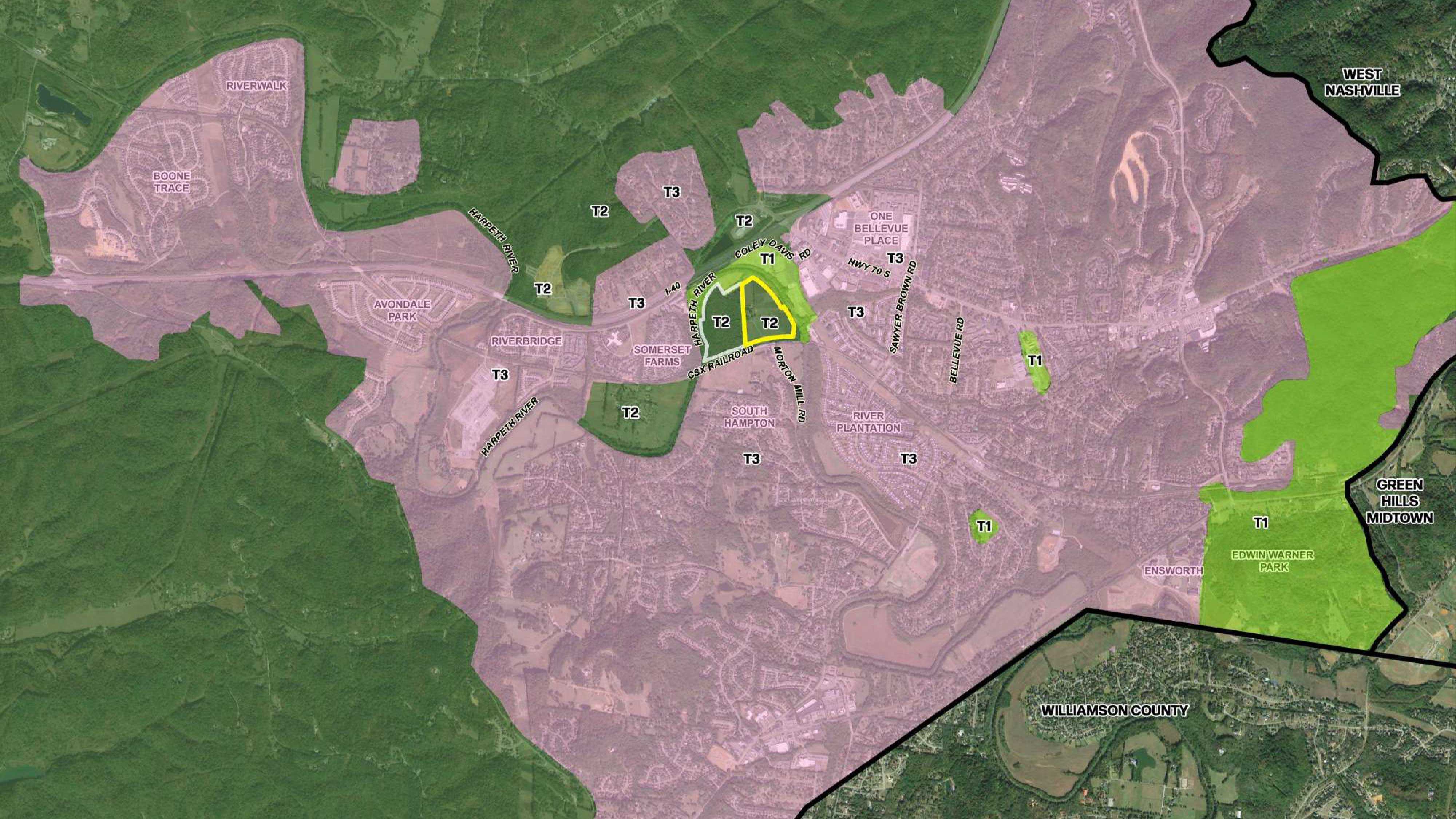
• The property is currently classified as T2-RM (rural maintenance) within the Bellevue Community Plan’s land use policy and the application requests a reclassification to T3-NE (suburban neighborhood evolving). Planning staff has indicated in previous conversations that the T2-RM designation was intended to ensure Planning had a voice in any future developments on the parcel such as the one we propose now. According to the Nashville’s Community Character Manual, T3 NE is intended for areas that are undeveloped or underdeveloped and suitable to be developed into residential developments at higher densities than classic suburban neighborhoods. This classification does not require any commercial space;
• The floodplain will remain CO (conservation policy); and,
• Once reclassified to T3-NE, Cypressbrook will request a zoning change from AR2a (agricultural) to SP (multifamily).
How do we hold the developers accountable for completing the bike paths in the way promised?
• As explained by the Planning Department in the July 7th community meeting responses, all of our commitments can be written into the accompanying regulatory Specific Plan (SP) zoning as legal requirement of any development of the property.
Is this spot zoning?
• Spot zoning is singling out a small parcel of land for a use totally different from that of the surrounding area. As exhibited below, the surrounding land uses are mostly already T3 (See graphic attached). This parcel is one of the few south of I-40 with a T2 designation and several members of our team were involved in the last overlay process. They have indicated it was deemed T2 only because of the challenges of accessing the site which our project addresses.

• This property is under contract by Cypressbrook Development, which is seeking to develop the property while providing Bellevue a connection to Metro Parks amenities.
What would the Open Space (OS) land use designation mean for the parcel currently owned by Metro?
• According to the Metro Nashville community character manual, the intent of OS policy is to preserve and enhance existing open space areas, most of which are publicly-owned parks and greenways. Metro Parks will continue to own the land and decide on the programming of the space in the future. Though future plans may include improvements such as trails and public facilities or other structures, our understanding is that the intent is for the natural character of the forested land to be preserved for future generations.
Suburban Neighborhood Evolving policy (T3-NE)
How will this development be consistent with the Suburban Neighborhood Evolving policy (T3-NE)?
• Buildings up to four stories may be supported in appropriate locations within the Suburban Neighborhood Evolving policy (T3-NE). The T3-NE policy identifies several factors when considering taller buildings, and this proposed development would comply with all of them:
- Adequate Infrastructure (water/sewer/complete streets/sidewalks/etc.).
- Access to Major Transportation networks.
- Opportunities for higher connectivity.
- Proximity to existing/planned transit, with increased height benefits for areas within .25 mile of a High-Capacity Transit Station.
- Ability to form transition from adjacent higher-intensity development to the lower scale neighborhood interior.
- Ability to support the viability of nearby consumer businesses.
- Ability to provide affordable/workforce housing.
- Water and Sewer is available in this area per coordination with HVUD;
- The proposed Public R.O.W. / bridge will provide infrastructure for vehicles, bicycles, and pedestrian traffic. Sidewalks throughout the development will connect internal amenities and units; and,
- The proposed greenway extension/connection offers a wide path for multi-modal pedestrian transit that will ultimately feed into the large Bellevue center.
- The proposed development entrance along Coley Davis is only a few thousand feet away from the Hwy 70S and I-40 Interchange and would have access to these two major corridors without going through any existing residential developments.
- The proposed development will extend/connect the existing greenways at no cost to the city, allowing existing residents and members of the community additional means to commute and utilize existing infrastructure; and, - Cypressbrook has agreed to raise Coley Davis above the 2010 flood level so residents along Coley Davis and residents of Ariza Bellevue have an egress route in the event of a 2010-level storm.
- The existing Coley Davis Road Shelter Park-N-Ride is located less than .25 miles from the proposed entrance into the development.
- The proposed site is largely isolated from nearby residential neighborhoods due to the CSX railroad, large TVA power lines, the Harpeth River, an existing 50± acre park, Coley Davis and I-40. There is a commercial center directly to the east of the property, which is a very high-intensity type of use; and, - The development team carefully located the four-story buildings furthest from adjacent single-family homes to provide a vertical transition in building form.
- The proposed development will further support the existing commercial uses not only by adding units/rooftops but also by providing a link with the greenway. This greenway connection (with some additional improvements off-site) will allow greenway users to access commercial businesses without a vehicle.
- Although the proposed units will be priced per market rate, diversity in housing types provides more affordable housing options compared to ownership.
• Suburban Neighborhood Maintenance (T3-NM) recognizes an established residential area with developed lots and a certain development pattern;
• Suburban Neighborhood Evolving (T3-NE) policy is for lots that don't have an established development pattern and allows for a variety of housing; and,
• T3-NE is intended to create and enhance suburban neighborhoods via greater housing choice, improved connectivity, and creative development techniques.
Would Metro consider doing a small land swap to more acreage above the flood plain to the developer to do 2 story upscale condominiums instead of apartments?
• No. Property currently owned by Metro Parks is prohibited for development via land swap. The proposed development is dedicating additional parkland to Metro Parks.
Parks and Environment Conservation
This community is surrounded by parks. Will this development endanger that?
• On the contrary, the proposed project will not only provide new park space but also access to transit to community members, connectivity to retail, and provide a key connection to a network of green spaces that improve long term community health.
Will this development threaten to pollute the Harpeth River or threaten the natural environment, including possible endangered species?
• The development team has conducted extensive studies including a Regional Constraints Analysis to ensure the development does not pose risk to the natural environment surrounding the site.
Schools
Will this project lead to further overcrowding of schools?
• We have analyzed this question from several angles. First, using Metro Planning’s calculation approximately 44 students attending local schools will live on site;
• Secondly, using our internal demographic data from comparable properties we have operated, we estimate the figure would be between 25 and 31 school-age children. If we pay taxes at a similar rate as the Sawyer at One Bellevue Place, which is our expectation, the portion of our property tax bill devoted to school funding will cover at least 40 students based on Tennessee Comptroller’s figures for the 2020 school year. This funding amount will offset all of the impact of new students if our historical demographics translate to this project as expected and largely offset the impact if the larger Metro calculation is accurate;
• Third, the Metro Nashville Public Schools capital budget for 2021-2022 shows Harpeth Valley Elementary at 78.8% capacity, Bellevue Middle at 74.6% capacity, and Hillwood High School at 69.7% capacity; and
• Accordingly, from all perspectives, there should be no overcrowding of the schools from the project.
Morton Mill Road Access
What is the long-term status of the current Morton Mill access road to the property over the over the CSX railroad?
• There will be an emergency only access point for the apartment, meaning we would have a locked gate that would only be accessible via lockbox controlled by CSX for their maintenance of the track and the City of Nashville Emergency services if Coley Davis bridge is not accessible. Based on usage at our existing and past apartments, this emergency access would rarely (if ever!) be used;
• Also, it’s worth pointing out that the current tenant has indicated the current crossing at Morton Mill gets daily use averaging 10-12 car trips-per-day and 15 truck or car-pulled horse trailers weekly as owners take their animals to other locations from where they are boarded on the current property. This traffic will all go away when the apartment opens; and,
• Lastly, we will be given a temporary construction easement across Morton Mill to be used only during the 12 to 15 months it will take to construct the bridge.
Resident Opposition
Bellevue residents don’t want another apartment complex in this area. Why are you building this in our suburban community and not elsewhere?
• Cypressbrook and its design team will continue to work with Metro Planning and Staff to provide Bellevue both a quality residential option and a connection that can expand multi-modal transportation in the Bellevue community;
• Nashville’s unprecedented growth will continue for the foreseeable future, which has created a significant need for more housing in the Metro area;
• Ariza Bellevue will not only help meet this demand but do so in a way creates needed greenspace and greenway connectivity at the developer’s expense; and,
• This property has been approached by development companies in the past and will continue as Bellevue grows. We are confident that we can provide a solution that is satisfactory for current residents, newcomers, and surrounding communities.
Is it true the property will have 1,400 residents at full capacity?
• During an interview with Channel 5, one of our team members misspoke and referenced this number inaccurately. This retraction was included in our July 7, 2022 Community meeting Q&A responses distributed by planning.
• We estimate there will be 600-700 residents on site.